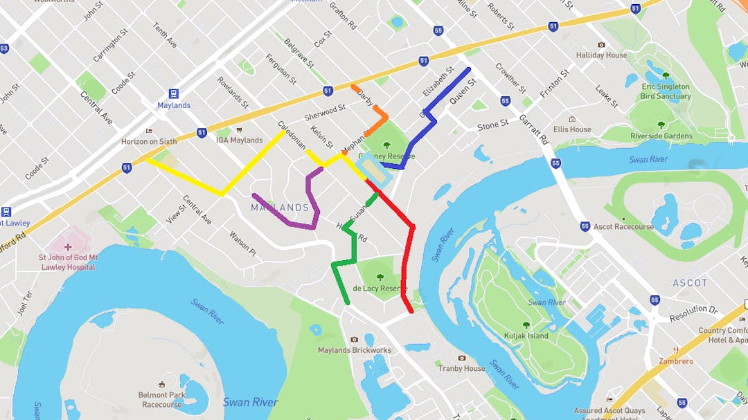
The ‘Safe Routes to School’ project aims to improve safety for our most vulnerable road users and increase walking, cycling and scooting to school as it is well recognised that this helps keep our kids healthy and happy.
To make it easier for parents and students to walk, cycle and scoot to school more often we will be identifying and providing pathway improvements, footpath stencils and wayfinding signage to six (6) safe routes to Maylands Peninsula Primary School.
This information will help us prioritise the work required to make the network safer and more enjoyable. The schedule (and time to implement) the work will be released depending on funding rollouts. The City will also be working with the Department of Transport's Your Move team on programs and signage.
Community Engagement
Submissions closed on Friday 20 May 2022.
An outcomes report for the engagement can be found here. This report summarises the survey results and provides an update on the program to date. All feedback from the survey was analysed and relevant issues were forwarded to the appropriate City departments for information and inclusion in future implementation plans.
What’s Next
Due to the availability of funds and prioritisation of projects across the City, improvements will be rolled out in stages. Some of the requested treatments can be addressed each financial year. However, the City is intending to incorporate requests into other existing programs that may assist in the delivery of some projects.
Background
The ‘Safe Routes to School’ project aims to improve safety for our most vulnerable road users and increase walking, cycling and scooting to school as it is well recognised that this helps keep our kids healthy and happy.
To make it easier for parents and students to walk, cycle and scoot to school more often we will be identifying and providing pathway improvements, footpath stencils and wayfinding signage to six (6) safe routes to Maylands Peninsula Primary School.
This information will help us prioritise the work required to make the network safer and more enjoyable. The schedule (and time to implement) the work will be released depending on funding rollouts. The City will also be working with the Department of Transport's Your Move team on programs and signage.
Community Engagement
Submissions closed on Friday 20 May 2022.
An outcomes report for the engagement can be found here. This report summarises the survey results and provides an update on the program to date. All feedback from the survey was analysed and relevant issues were forwarded to the appropriate City departments for information and inclusion in future implementation plans.
What’s Next
Due to the availability of funds and prioritisation of projects across the City, improvements will be rolled out in stages. Some of the requested treatments can be addressed each financial year. However, the City is intending to incorporate requests into other existing programs that may assist in the delivery of some projects.
Safe Routes to Maylands Peninsula Primary School has finished this stage
This consultation is open for contributions.
Under Review
Safe Routes to Maylands Peninsula Primary School has finished this stage
Contributions to this consultation are closed for evaluation and review. The project team will report back on key outcomes.
Final report
Safe Routes to Maylands Peninsula Primary School has finished this stage
The final outcomes of the consultation are documented here. This may include a summary of all contributions collected as well as recommendations for future action.
Funding being finalised
Safe Routes to Maylands Peninsula Primary School is currently at this stage
The projects have been approved, and are allocated to the appropriate departments to coordinate funding and rollout schedules.
Construction works
this is an upcoming stage for Safe Routes to Maylands Peninsula Primary School